Похожее видео
×
How Tornado and Stormchase Nowcasting Works.
Видео: How Tornado and Stormchase Nowcasting Works.
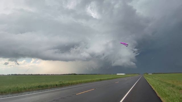
Its finally the height of storm chasing season. We count the days till the season opener its been 9 perhaps even 11 months since the last big storm. Or if last year was 2020 perhaps its been nearly 2 years since scoring the real prize we are looking for. A photogenic fully condensed tornado under a classic supercell over we hope open country. This far into spring we may have already seen lightning felt that first rain cooled gust of wind. heard the hail and thunder smelled and tasted that sweet petrichor. But now its time. For the perfect storm chase. Realtime observations. Its Time to nowcast. Discord? Patreon? Twitter? On April 23 2021. My initial target was somewhere between Wheeler and Puducah TX. There is also more than one target this day for tornadoes. At first glance it might seem tornadoes are more likely here ne of Dallas. Or perhaps CAMs have also suggested here up by Interstate 40 is the best play. Messy convection that possibly produces tornadoes isnt what Im after. And Im not exactly looking for a low probability play elsewhere. I want to know where isolated storms are expected and where does that coincide with the best parameters for tornadoes thats something Ill dive into over future storm chasing videos. Nowcasting is perhaps a slang term but a nifty word to describe the game of stormchasing when in the moment. Its understanding what is happening and responding to it. Where do you need to be what are you going to see when will you see it. Calculations you are constantly making. Nevermind all of that is being interrupted by trying to enjoy photograph and document those moments as well. You must gather all the intel you can about current and near future conditions. The road network ahead of you. your surroundings. your goals your options. Observed soundings show storm motions of about 35 mph going East-north-east. I also know that generally storms wont be quite as fast advertised and tornado producing storms tend to right turn perhaps East South east in this case. And while Texas and oklahoma roads in this area are a bit on the sparse side speed limits are about double storm motions. I have to consider the red river and the few road options across it should a storm switch sides. But Overall this gives me enough confidence to be on storms as soon as they fire even if im only expecting tornadoes to happen later. As a storm matures and strengthens its time to look for clues that tornadogenesis is imminent. Clearly this is a rotating supercell but now has right turned avoiding the red river completely. A relief as well as a sign of things to come. An inflow tail suggests the updraft of the storm is ingesting rain cooled air above the surface a sign of further strengthening. From this vantage point east and north of the updraft the inflow tail can even direct you to exactly where a tornado would form just below the end here. A tornado may be imminent. But I need to stay ahead of this storm which is now drifting ESE instead of ENE. So in a risky move I translate south of the storm. While doing so large hail from the rear flank downdraft begins to wrap around attacking me in the process. Ominously tornadogenesis has just begun directly above me as well. I should have moved a minute or two earlier to increase my safety margin. This supercell began to run into neighboring storms quickly growing upscale. This is normal expected behavior most times. It means photogenic tornadoes are essentially over However now Its time to switch to documenting all the awesome textures and wild colors of the dynamic back side of the storm. Complete with mamatus anvil crawling lightning and golden hour lighting. As an added bonus a high based funnel appeared on the backside of the storm as if to say thanks for sticking with me. As the front raced in a shelf cloud was produced under weak thundershowers. If you are interested in seeing more videos like this Ive been working over the years on a series of videos spanning North America supercell climatology forecasting and observation and more. Click the playlist in the upper right if this sounds good to you. And while I have you hit that like button subscribe or leave a comment. Until the next one Ill see you out there. Normally I dont intentionally chase a storm from behind. Often tornadoes can get lost in rain from this angle but today would prove that to actually be a good idea this time. From a southward vantage point the horseshoe shape of the wall cloud is most apparent. The north side of the horseshoe is what Im watching for new tornado development. I give this area some respect however less often tornadoes may spawn here as well.,

2026-04-21 в 23:30:33


2026-04-21 в 22:47:16
2024-05-02 в 07:51:39


2026-04-21 в 22:48:55

2026-04-21 в 22:21:38
2024-05-02 в 07:28:56


2026-04-21 в 22:23:47
2026-04-21 в 22:12:59