Похожее видео
×
Agricultural Mapping with Drones and Satellites
Видео: Agricultural Mapping with Drones and Satellites
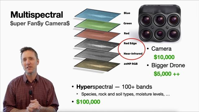
KBFA Advisor Andrew Bennett describes how he uses one of the least expensive drones available and free software to make base maps and 3-D topographic maps. He also shows where to get free satellite data to map the productivity of any farms vegetation through the seasons. 00:00 - Intro 01:15 - Mavic Mini 2 02:58 - Basic Maps 04:41 - Map Quality 06:05 - Autopilot 07:14 - Licensing 08:01 - Big Farms 08:50 - LIDAR 09:52 - Satellites 10:13 - Productivity Maps 11:14 - NIR Drones 13:10 - Light Waves 14:32 - Plant Reflectance 17:02 - Satellite Data 18:46 - FBN 21:09 - Earth Explorer 24:20 - QGIS This video is part of the Agricultural Drones series hosted by Kootenay Boundary Farm Advisors on March 18 2021. Separate videos and transcripts for each of the following presentations are available at www.kbfa.ca: Introduction to the Agricultural Drones series Latest Ranching Drone Research with Dr. John Church Thomson Rivers University Associate Professor Big Rig Spraying Drones and Nanotechnology with Chris Noske Pro Ag president Drones for Farm Record Keeping with Tony Jeske Ranch Mapping through the Seasons with Devin Chursinoff maps made by Jon Wilson of 4 Elements Emergency Consulting Grand Forks BC ,


2026-04-21 в 08:52:50


2025-02-04 в 15:47:17


2026-04-21 в 08:44:08