Похожее видео
×
Download OpenStreetMap Spatial Data using QGIS OSM Downloader Create Shapefile
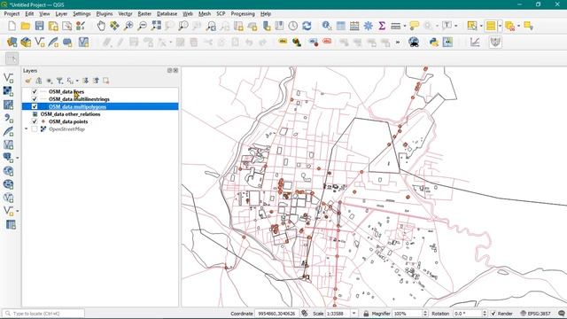
Видео: Download OpenStreetMap Spatial Data using QGIS OSM Downloader Create Shapefile
These are very Time-saving tricks. Today we will learn How to download OpenStreetMap data using OSM Downloader. Important topic covered in this video: OpenStreetMap OSM Downloader Shapefile creation using OSM Downloader Remote Sensing and GIS Book - MY MIC - MY LAPTOP - HP Ink Tank Printer - MY Keyboard and Mouse - Bluetooth Headphone - Previous Video: Showing Correlation Between NDVI and LST using QGIS Relation Between NDVI and LST Easy Way to Create NDWI NDVI and LST Land Surface Temperature Map in QGIS Point and Line Digitization in QGIS Create Point and Line Shapefile Create Shapefile using Polygon Digitization in QGIS Using Snapping Tools Create an Account and Download Landsat 8 Satellite Images From earthexplorer.usgs.gov Remote Sensing and Spectral Reflectance Active and Passive Sensor Step by step we will cover each and every topic on LULC and Change Detection. Whatever documents and files will be needed in this series we will upload it on our official website: if you face any issue. Feel free to comment. Previous Video on Create Map Layout in QGIS Print Layout Latest playlist on Terrain Analysis Slope Aspect and Hillshade: Our official website: Previous Videos: Land Cover Supervised classification using Semi-Automatic Classification Plugin on QGIS Download LISS_III Satellite Images From Bhuvan.nrsc.gov.in Bhuvan Satellite Images Download Like our Youtube Channel for the next update and videos. For any queries E-mail admingeographicalanalysis.com OpenStreetMap OSM_Downloader QGIS,

2026-04-20 в 02:53:39


2026-04-20 в 04:01:03
2023-09-20 в 22:51:09

2023-09-20 в 23:01:33


2026-04-20 в 02:46:18